Pioneer Days
What of the battle at Ntaba-zika-Mambo?
“Wilder country than the Mambo Hills can scarcely be imagined: even the Matopos seem tame in comparison” (Ransford 1968: 112). Plumer was despatched with a large force to attack this area as Carrington deemed it the more dangerous arena due to the reports he had received about the concentration of Matabele forces there. Plumer's 700-odd “stealthy band of khaki-grey intruders” (Stent 1925: 15) reached there on in the wee hours of July 5 after a night march from Inyati and the result was hailed as a great victory for the colonial forces. Stent (1925: 17-18) leaves us an eloquent account of the start of the battle:
Among the hills the musketry began to bubble incessantly. The dawn glowed red. The thud of mountain guns echoed amongst the granite boulders. The sun rose, searching and unwelcome to the enemy. The Matabili were making stand in a central kopje – a nasty one to tackle... [Pursuit of the Matabele started.] One man drew out ahead, in spite of warnings and expostulations. I spurred to see. It was Rhodes himself, riding unarmed, switch in hand, leading the hunt. Cobbing (1976: 420-421) claims the battle was fairly one-sided since the majority of the forces had already withdrawn, leaving the women children and domestic stock behind, guarded by a few defenders. With his usual humour and flair, Sykes (1897: 162) mentions in passing that the morning service for the start of this day was I Samuel:15-24 which describes Saul's expedition against Agag and the Amalekites, together with the capture of a large number of sheep and oxen.
The Mambo Hills
Quoting Major Robertson, commander of the Cape Boys, Sykes (1897: 137-138) has left us with the following description:
Thabas Amamba consists of a range of hills running north and south, and rising abruptly from a plain which is seen gradually ascending in an easterly direction. The range is about five miles in length. Along the western slope the face of the hills is almost precipitous, with numerous clefts and gorges opening to the country beyond... The top of the range may be described as a series of peaks somewhat elongated in a northerly and southerly direction, having for their summits gigantic granite boulders piled on the top of each other... Large openings between the boulders form hundreds of natural caves. The bush known as the 'wach-en-bitjie' thorn and multitudes of different kinds of creepers, also of a thorny nature, grow in abundance in every nook and corner where it is possible for roots to get a holding... there are numerous valleys, some not more than 100 yards, others nearly a mile in width, all of them intersected with watercourses and overgrown with dense bush, with but few clearings... The stronghold itself rises out of this watercourse, with an almost precipitous face, to a height of 500 to 600 feet, formed of gigantic boulders, with innumerable caves of great dimensions, and a perfect maze of thorns and shrubbery.
Baden-Powell (1897: 280) is more poetic:
The rocks and koppies here like those in the Matopos are, piles of granite boulders, and in many cases assume most fantastic forms. Here and there they look like castles on the top of peaks; in other places, like gigantic loaves of bread; and in one place there was a tower of five of them placed on top of the other for a height of nearly a hundred feet.
So it was a walkover?
Plumer's (1897: 135-136) dry prose hides vivid battle scenes:
The enemy were not discovered in any force till 6.45 a.m., when the scouts came upon a considerable number near some scherms. They were evidently surprised, and were driven from their position – one of some strength – without much difficulty. They however retired into some koppies overlooking the river where they made a protracted stand. The position was of great natural strength, the koppies being high, difficult of access and honeycombed with caves from which the rebels kept up a continuous and fairly accurate fire... One koppie was taken by the B.F.F. About 9 a.m. and at 10 a.m. the main one was stormed by the Cape Boys under Major Robertson, supported by about forty men of the B.F.F. The cape Boys attacked and carried the position in a very determined and gallant manner in the face of a hot fire, killing a number of the enemy and driving the remainder from the koppies. During the next hour lot of desultory fighting took place, and it was not till 12 noon that the koppies were practically cleared.
What is clear from this account is that this fight was not the great victory trumpeted by the press at the time. Sikobokobo's men from the Induba fought extremely well and “in many cases their shooting was very good” (Plumer 1897: 138). There seems to have been great difficulty in coordinating the battle. “[A]ll dissolves into an impression of a savage series of hand to hand skirmishes” (Ransford 1968: 114). According to the official reports, three whites were killed outright, five wounded and one died of his wounds the next day (Stent [1925: 22] and Ransford (1968: 114) claim 18 were killed, and Ranger (1967: 234) 9 dead, figures that do not gel with official reports; perhaps Ranger combined the casualty figures). The Cape Boys lost six killed and nine wounded while Matabele losses were estimated at 100 dead. Strangely Ranger (1967: 229-234) turns this battle into a sort of last stand for the Matabele forces in the north without considering the prior movement of these soldiers into the Matobo Hills and the Shangani and Somabhula areas. The whites captured a great deal of cattle and other domestic animals and prisoners which were taken back to Bulawayo.
What was the ultimate importance of the battle?
Stent described the burial of those killed in the fight, ending with the words “This rough and hurried burial of the men who had given their lives for Rhodesia brought home to [Rhodes], as nothing else could have done, the meaning of war – the cruel bloodiness of war”. For the man who could do the most to end the war, reality hit home. The whites were not going to win by force of arms alone and as Rhodes brooded over the camp fire that night, “it was then that there came to him the idea of meeting the Matabili themselves, learning what they fought for, and trying to bring about Peace” (Stent 1925: 23).

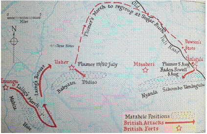
Map showing battles fought in the Matobo Hills (from Ransford 1968)
Sourced from the Zanj Financial Network 'Zfn', Harare, Zimbabwe, email briefing dated ? 2011


 South Devon Sound Radio
 Museum of hp Calculators
 Apollo Flight Journal
 Apollo Lunar Surface Journal
 Cloudy Nights Classic Telescopes
 The Savanna - Saffer Shops in London
 Linux Mint
 Movement for Democratic Change